
What is a Drone survey
Traditional land surveys typically use ground-based equipment using Lidar Scanners mounted on tripods to measure distances between points in a construciton site accurately.
With drones becoming more affordable, many construction companies like Kier, Balfour Beatty, and Vinci Construction are starting to use drones to conduct such land surveys on a site more quickly and affordably.
Drones can cover large plots of land very rapidly. Whereas a traditional land survey could take up a a few days up to months, a drone survey can cut down that time by up to 90%.
What can you do with drone surveys?
There are currently many models of drones available in the market today. These drones or Unmanned Aerial Vehicles (UAVs) can be enhanced by mounting additional equipment like onboard sensors or highly accurate LIDAR technology. These technologies fulfil additional needs that cannot be fulfilled by a consumer-model drone.
Generate a 2d orthomosaic map
An orthomosaic map has a uniform scale throughout the entire map. It consists of multiple drone shots stitched together and corrected such that it is equivalent in accuracy to a map.
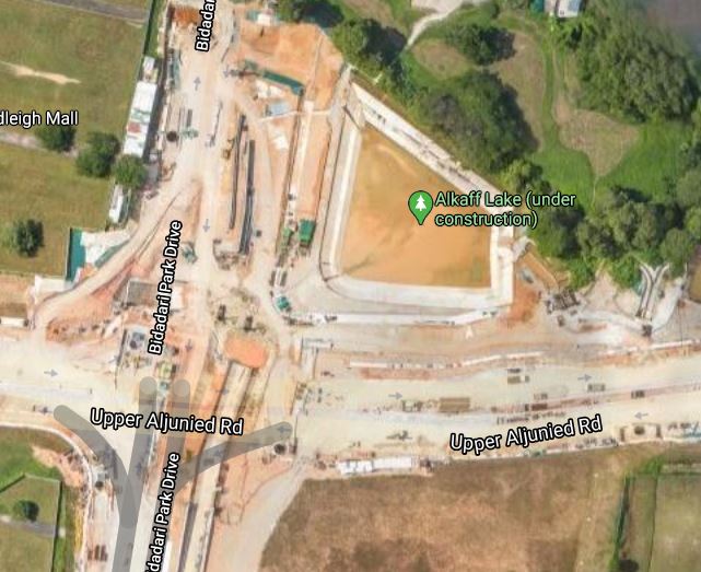
Orthomosaic maps are often used by real estate companies to create a detailed overview of an entire property. These are often used in plots of land that are large, and would take a large amount of time to cover on the ground.
In the construction industry, orthomosaic maps can help you zoom in on ground features on the map. By creating regular snapshots at pre-defined intervals, it enables project managers to keep track of project progress.
Generate a 3d map of a building or a feature
For companies that wish to be able to keep track of the building progress of the exterior of a building, a 3D orthomosaic map would be more suitable.
Using a tool like Autodesk ReCap, the drone scans can be imported into BIM software like Revit. After post-processing, the scanned BIM model can be cross-referenced with the design BIM model.
Project managers can now detect deviations of the as-built model from the planned BIM model. Detecting and correcting these issues early in the construction process will reduce the significant costs of constrution rework later on in the project lifecycle.
High-accuracy land surveys with lidar
For construction companies, it is critical that the map output is created with a high degree of accuracy. This is critical for project tracking purposes and can provide useful documentation when dealing with litigation issues.
Some companies utilize LIDAR that uses beams of light to obtain accurate distance information. When combined with a drone that is mounted with a PPK receiver, highly accurate distance information ( < 1-inch ) can be produced alongside GPS information.
How do i start get started with site surveys using drones?
It really depends on what you as a company needs. For highly accurate maps created from drones, additional equipment such as PPK or RTK sensors need to be deployed to increase measurement accuracy. Even image quality depends on the respective drone model.
To reduce the cost of drone mapping, some consultants work with specialised drone operators to create mapping data. This reduces costs because companies do not need to purchase their own drones or invest in employing someone with the skill needed to operate a drone.
This model makes sense because site surveying requirements typically only come in early on in the construction processs. If you are a consultant, contractor, or business that is keen on adopting drone surveys into your workflow, you can get in touch with us.